Yeah, I’m expecting our new generator will get its first real workout this weekend.
@clay Friday night may turn out ok. I think the worst periods are supposed to be late Thursday and then sat afternoon/evening.
Yeah, I’m expecting our new generator will get its first real workout this weekend.
@clay Friday night may turn out ok. I think the worst periods are supposed to be late Thursday and then sat afternoon/evening.
So we’re getting a mini heat wave later this week.
This is the maybe 2nd or 3rd time this has happened in the past month or so. It’s cool, it’s hot, it’s cool again. It’s so confusing. Usually, we get a steady heat wave for maybe a month or so, and then temperatures fall. Now it’s a weird-ass rollercoaster of temperatures.
Climate change is bullshit! What are you saying? GRRRRR!
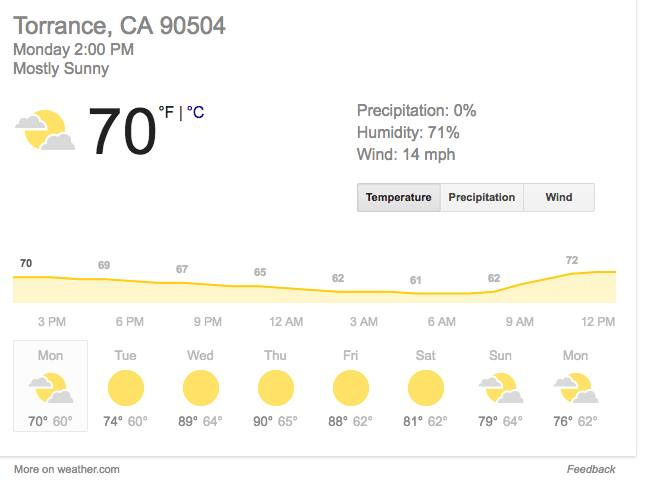
This also happened today.

Way above normal here in Toronto, and in another weird sign, there are tons of mosquitoes around. Never had them this late in the year before.
That does sound weird.
I thought last year was an anomaly. After living in Oregon since 1989, I hadn’t seen so much rain ever.
This fall rain season is doubling down.
October will go down in the record books with the most days of rain the month has seen in several parts of Oregon, according to the National Weather Service.
Sunday marked 27 October days with measurable rain in the Portland area, and Halloween will likely make 28, said Gerald Macke, a meteorological technician with the weather service in Portland. The previous record was 23 days in 1947 and 1950.
Why is Oregon so greedy? Stop taking all the rain from the clouds and save some for us folk east of you. Jeez.
East? How about south! I mean we are just going to steal the East’s water to begin with so you might as well skip the middle man.
I don’t think you understand how rain works up here. Those 28 days constitute about 8 inches of rain. I remember when we moved from Florida and told people where we were going. Every last one said, “but it rains all the time there.” Of course, they get more inches of rain in Florida every year , it just happens in much more compressed periods.
Well the way rain works down here is… it doesn’t, for a good chunk of the year. And it’s clearly because Oregon has rigged the weather!
Mother nature has shut down portland
8-10" of snow, another 3-5" expected.
Meanwhile Central and Eastern Europe are having a serious snowpocalypse. It reached -30 C in Moscow the other day, -20 in Romania, and Bulgaria, Romania, Greece and Turkey are no longer sharing electricity.
My sister is a wildlife biologist in the Lake Tahoe region. In some ares of the Sierra Nevada range they’ve seen six feet of snow and they’re looking at a total snowfall of 10’ before the storm abates. That’s 120 inches.
And the irony is that there’s a chance that this doesn’t raise the water tables out west.
At first I was like ‘that’s great news! That water will propagate to the Bay area with the spring melt, and snow melt is one of the best ways to recover water from a drought’
Then I looked to see the outflows, only to discover the single outflow ends at Pyramid Lake, which has no outflow itself. Nature be trolling.
Hopefully the area just west of Tahoe is getting as good, because only a dozen miles west is one of the primary watershed feeding areas for the Bay.
Hmm, guess I should have posted about Portland’s ridiculously big snowfall last night in this thread–over a foot, in a city that often goes two or three winters in a row with no snow at all.
Overnight last night we had 100km/h (60 mph) wind. Today it’s plus 7C and heavy rain. Sounds ok for storm season in the Carolinas. But I live in Toronto.
We had a an Arctic front roll through Montana in mid December that dumped over a foot of snow where I live, followed by -20 F temps. The combination was enough to close schools for a day.
The only other time I can remember the schools actually closing due to weather was during my 8th grade year, 1989. After some digging I found some details about the storm that I failed to appreciate as a kid.
From: https://www.wunderground.com/blog/MTWX/top-ten-montana-weather-events-of-the-20th-century
"#4). January 30 through February 4, 1989. A bitterly cold Arctic air mass invaded the northern Rockies bringing record cold temperatures and extreme wind chills to Montana. Ahead of the front, on January 30th, downslope winds gusted to 100 mph at Shelby, 102 mph at Cut Bank, 114 mph in Augusta, 117 mph at Browning and 124 mph at Choteau. Twelve empty railroad cars were blown over in Shelby. Elsewhere, roofs were blown off homes, mobile homes were rolled over or torn apart and numerous trees and power lines were blown down.
With the passing of the Arctic front on the 31st, temperatures dropped dramatically. In Helena, the temperature remained colder than -20°F for 84 hours (three and a half days) including a record low, -33°F on the fourth. Wind chill values during this period dropped to -75°F. The cold caused the brakes to fail on a freight train. The train then rolled, uncontrolled, into Helena and exploded causing extensive damage to Carroll College.
In Billings, record lows were established for 5 consecutive days. Bozeman set record lows for four consecutive days. In Missoula, record lows of -22F and -23F were established on the 2nd and the 3rd, respectively. Wisdom, Montana, saw the mercury drop to -52°F on February 3rd.
As the cold front moved through Great Falls on January 31st, the temperature dropped from 54°F to -23°F (a 77°F change) and did not rise to above -20°F until February 4th. This included two record low temperatures (-35°F and -33°F) on the 3rd and 4th.
Between January 30th and February 5th, four people lost their lives with damage estimates well into the tens of millions of dollars. "
I’m seeing pretty deep snow in friends photos from Istanbul. It doesn’t seem to have gotten as far east as Lebanon though.