Yea, i’m trying the console port now and it’s pretty grand… a much smoother experience (as far as loading, stability goes) than my 1080 PC system.
I’ve taken some flights on the series x, and it runs very well. It’s crazy being able to see my own house in game.
Finally got home and got to fire this up on the Xbox and it seems pretty cool! Though I confess I’ve still got my training wheels on, going through the tutorials. Seems like using the controller is very touchy, like I’m constantly oversteering and then overcorrecting, it’s hard to find the right pressure to just maintain heading and altitude. Though I’m sure I’ll get a better feel for things as they go.
Trim is your friend. The idea is to point the nose where you need it then use elevator trim to relieve the pressure and allow you to let go of the stick. Also it’s probably a good idea to adjust the controller sensitivity to your liking.
Gah, looks like the bindings issues with the update have brought back this situation, and I can’t remember which binding I deleted to fix it last time. I don’t seem to have anything bound to mix. Really don’t want to have to set my X52 bindings back to default.
About 20 failed tests and a few uninsured crashes later*, I finally have my class E licence in Neofly. Hooray! Now I just need to pay off the, um, $18m debt I incurred.
- Note to self: make sure the airport you take the test at has a long enough runway.
Like this? I think the Garmin isn’t taking into account the new takeoff and landing distances - it’s showing the old end-of-departure-runway to start-of-destination-runway, whereas in reality you’re following one that factors in takeoff and landing distances.
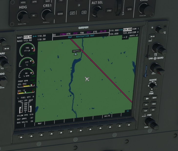
What you’re seeing is the autopilot adjusting for wind.
One thing I really like about the update is that jacking up the sim rate for long flights no longer sends my CPU temps into the 80s even with the fans on max, or tank my frame rate. The only jet engines are in-sim. Stays super smooth and none of the cores are over 3GHz. GPU doesn’t get hot either, but then it never did.
Whoa, really? Is this new? I don’t remember seeing it do this before so I can’t tell if that’s a change or me changing to using live weather.
Same here. Plus with the Shift-Z mod I SEE which frame rate I’m at.
If you’ve never had wind on your flights before (lol) you won’t have seen it. It isn’t new. The GPS shows the straight line route, but wind will blow you off track if you fly the precise heading, so autopilot adjusts for it. Even the old gyropilot in the DC-6 can do it when tracking a VOR.
Strange, I’m SURE I’ve had wind but I remember that I think I was flying through thunderstorms (near the King Air location) the other day, perhaps it was exactly that. Strong enough that I noticed it. I feel relieved but also embarrassed if so. I just thought the update messed with autopilot.
Yeah, Lionel is a very pleasant and helpful guy in “person”, too. :)
OK, hadn’t gotten to the tutorial explaining how to adjust trim yet when I posted, but I get it now. I’m having fun working my way up to being an “actual” pilot, doing the Cessna training. One day I’ll fly by myself!
Wind correction will cause your heading to differ from your track, but it shouldn’t cause a steady XTE of what looks like about a mile here.
I’d need to see the full flight plan to suss things out completely, but I have a suspicion as to what you’re seeing here – and it’s only an educated guess based on what I have here and my background knowledge. I can chat with the guy who did most of our map-drawing work on the NXi to get fuller details.
At any rate, the MFD map (as used in the sim) is a Mercator projection.* In the stock instrument, your flight path is drawn as a more or less straight line between A and B. For the most part you can’t just draw a straight line on a flat projection and get a 100% accurate track of what the spherical path would look like. Looking at any great circle route over a long distance will demonstrate this clearly. :D
I suspect that what you’re seeing here is the difference between those two. I’m pretty sure (though I’d need to check with our map guy to confirm) that we put a fair bit of custom logic into the NXi to more accurately draw those paths. It’s a surprisingly hard thing to get right.
That’s my guess, anyway. I’m pretty sure it’s not the wind, at least. :)
(* The base map in the game is drawn directly from Bing data, and is referred to throughout the code as “bing-map”. It’s visible all over the human readable JS source, too, so I’m not spilling any secrets, there. This makes it pretty much impossible to change how the map itself looks or is drawn, aside from tuning colors. Everythign that is drawn on top of the map, though, is done in userspace, so you can customize all the icons and lines on top of it, but not the terrain directly.)
I found the compass in the cockpit view of the plane in the Padagonia bush trip.
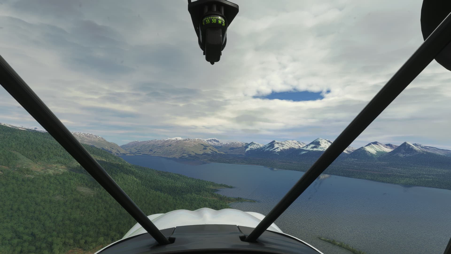
I had to look up!
I’ve done this leg of the trip 4 times now, the landing strip is so small. In the old yellow plane from the Breckinridge bush trip, I could have done this landing in my sleep. That plane stopped dead once you cut the throttle and lowered the flap. In this plane, I had throttle at zero for a full minute with flap lowered for about 20 seconds before the landing. I was still coming in too hot.
I guess next time I need to do the leg again, and try lowering the flap a full minute before the landing too, along with the throttle. I’m still used to not being able to go very far in that situation in the other plane, but I guess it might work in this plane.
Just for the fun of it, here’s what flying into a 70kt crosswind in a Cirrus looks like while following a DTO with a centered CDI.

If you’re trying to lose altitude (or speed) in a hurry, another thing you can try is a forward slip. Put in some aileron, while at the same time adding opposite rudder. This puts you into what’s called a “cross-controlled” state, and it induces a large amount of drag, which burns energy quickly.
It takes some coordination, and a bit of practice to get right, but once you get the feel for it it’s a very useful tool to have in your bag of tricks for when you want to turn into a giant piloted speedbrake.
See, this is what I’ve experienced. I was VFR flying a GPS route, that tracks instantly based on destination, not like a VOR where my actual path could span around a radial. So being that far off threw me and yet … I was on-path in external view. Something was off, perhaps as @Paradroid is saying the display is factoring wind, but … why with a GPS track? I dunno. I need to see if I can reproduce it now that weather is calm in that area I was flying.
Had some real weird behaviour on my last flight in a Longitude. The ATC consistently thought I was about 800ft lower than the instruments were indicating, even after adjusting baro. A lot of the time the engine seemed to be in overdrive despite my autothrottle IAS being near or below 200. And every minute or so (at high sim rate) I’d get hit by something that may or may not have been turbulence (I suspect it might have been the engines crapping out), but was far more dramatic than anything I’ve encountered before, immediately knocking me 2000 feet up or down and sending my N1% and ITT all over the shop. Hoping it was just a one off, but I wonder if whatever was causing the weird high altitude temps was also causing this and hasn’t been fixed.